You are here:Home-administrator

About administrator

This author has not yet filled in any details.
So far administrator has created 84 blog entries.

Sector Assessment Forms (Team management website)

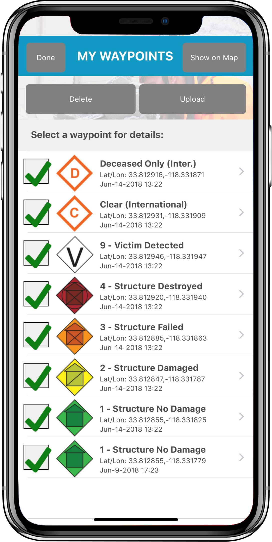
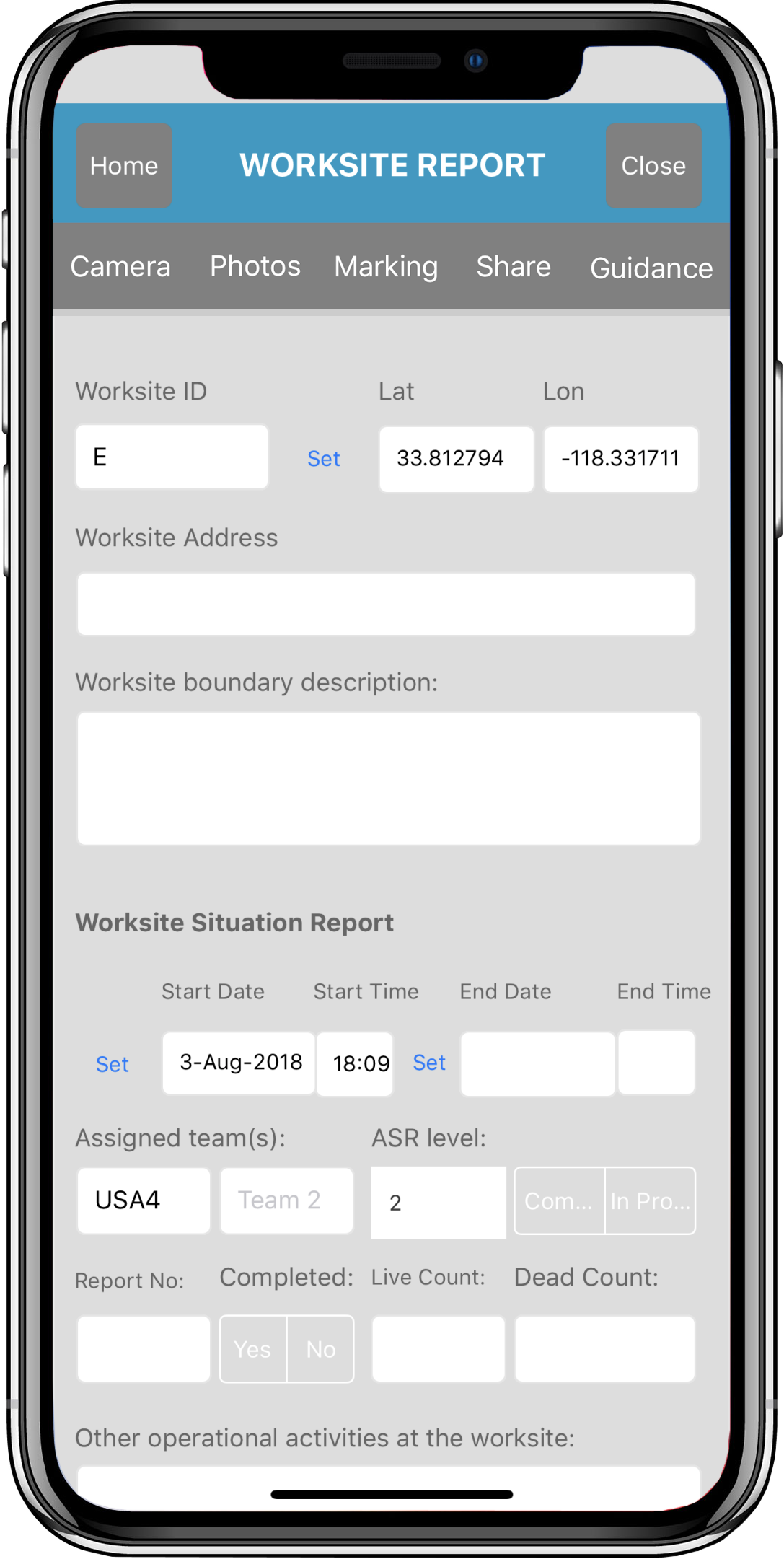
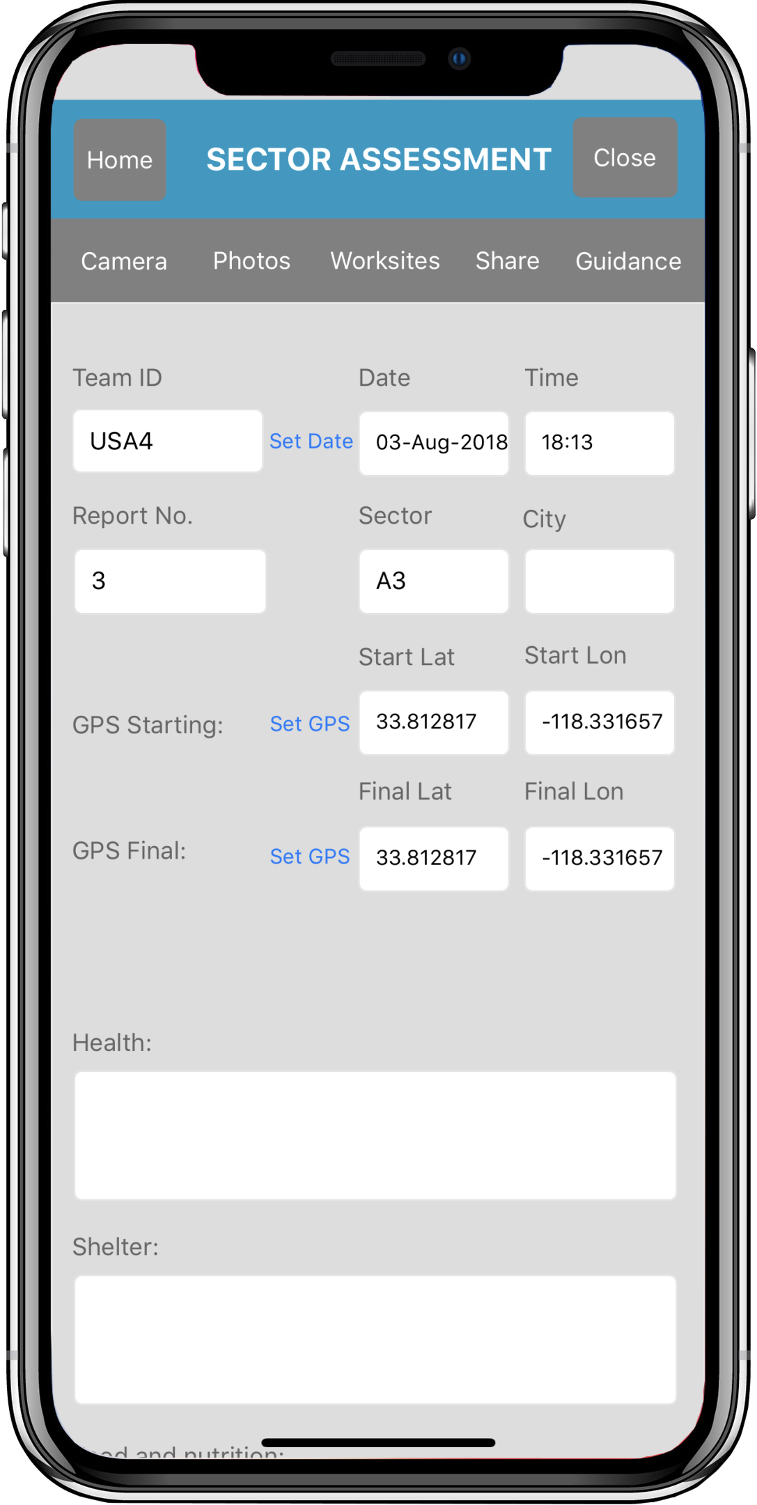
The commander edition website displays all team member sector assessment forms at a glance in a list, and displays a count of any attached sector assessment forms and waypoint markers. A list of all worksite triage forms and any waypoint markers associated to the

By |2017-09-18T15:17:58-07:00September 18th, 2017|Categories: Commander website|Comments Off on Sector Assessment Forms (Team management website)

Victim Extrication forms (Team management website)

The commander edition website displays all team member victim extrication forms at a glance in a list, and can be displayed on a map for better situational awareness, geographically. The popup windows contain previews for any photos taken for the victim, and clicking a link allows sharing of

By |2017-09-18T14:50:09-07:00September 18th, 2017|Categories: Commander website|Comments Off on Victim Extrication forms (Team management website)

Worksite Triage forms (Team management website)

The commander edition website displays all team member worksite triage forms at a glance in a list, and can be displayed on a map for better situational awareness, geographically. The popup windows contain previews for any photos taken at the worksite, and clicking a link allows

By |2017-09-18T14:11:15-07:00September 18th, 2017|Categories: Commander website|Comments Off on Worksite Triage forms (Team management website)

GPS Tracks and Waypoints

The GPS and Waypoints features of Disaster Surveyor have been designed with years of real world search and rescue experience to focus on the key core features that have been found useful over time. In addition to the main GPS bearings, Disaster Surveyor can keep

By |2017-09-16T22:40:04-07:00September 16th, 2017|Categories: Android, Apple, Apps|Comments Off on GPS Tracks and Waypoints

Area Maps

The Area Maps section of the app contains a variety of useful tools for both online and offline maps. Options for maps include loading pdf maps via URL, via Dropbox, via QR/Barcode scanning of a pdf map URL, or generating a live map object and saving for

By |2017-09-16T22:13:12-07:00September 16th, 2017|Categories: Android, Apple, Apps|Comments Off on Area Maps

Worksite Report Forms

The Worksite Report forms are the overall worksite situation report for rescue counts, deceased victims recovered, current status of operations, and information related to the particular worksite operation such as ongoing worksite planing information, local activities, resources released, any local emergency contact info, and more. The forms

By |2017-09-16T21:34:59-07:00September 16th, 2017|Categories: Android, Apple, Apps|Comments Off on Worksite Report Forms

Sector Assessment Forms

The Sector Assessment forms help create an overall picture of the entire sector including all its worksites and victim forms during search and rescue operations. The forms comply with United Nations INSARAG sector assessment forms. The home screen for your sector assessment forms displays a checkbox to

By |2017-09-16T21:17:01-07:00September 16th, 2017|Categories: Android, Apple, Apps|Comments Off on Sector Assessment Forms

Options and Settings

Disaster Surveyor has several options and settings that are cognizant of the type of unexpected emergency environments and countries an International USAR team, or even a domestic team when all power is out may encounter. The settings screen allows the user to set GPS tracking interval time, GPS tracking

By |2017-09-16T20:55:55-07:00September 16th, 2017|Categories: Android, Apple, Apps|Comments Off on Options and Settings

Victim Extrication Forms

The Victim Extrication forms gather information about victims found in a disaster worksite. The forms comply with United Nations INSARAG victim extrication forms. The home screen for your victim forms displays a checkbox to indicate which forms to upload when the 'Upload' button is pressed and

By |2017-09-16T20:45:40-07:00September 16th, 2017|Categories: Android, Apple, Apps|Comments Off on Victim Extrication Forms

Other Features

Disaster Surveyor includes a simple text-based team chat. Every photo saved directly to a form can also be detached and reassigned to a different form using the master photo gallery. The side menu also includes a INSARAG field guideline as pertains to Urban Search and Rescue.

By |2017-09-16T20:13:35-07:00September 16th, 2017|Categories: Android, Apple, Apps|Comments Off on Other Features
Go to Top