Frequently Asked Questions
Yes, Disaster Surveyor apps and standard team management website tools are available for use free by local, national, and international Urban Search and Rescue teams around the world. Our current Standard edition apps and tools will always remain free, while future premium versions with additional features will require a subscription or support package for your organization.
All Disaster Surveyor app accounts and data by teams are securely stored on DoD Level 5 servers on our Amazon AWS networks. Our user data will never be shared or sold to any 3rd party outside of Disaster Surveyor Systems, Inc.
Our premium team management tools include: (a) Archiving of your team’s forms data (for international users) and waypoints data (all users), (b) Ability to post your waypoints to any ESRI ArcGIS Hosted Feature Layer (for use with any Operations Dashboard), (c) Ability to send SMS-based team dispatch, and (d) Ability to send and receive SMS-based team messaging. Please see our Premium Features page at https://www.disastersurveyor.com/premium-features/.
You may purchase a single individual user license that is used as part of a team, or, a team leader may purchase a discounted multi-user pack, and apply that to their team members. If a 2nd person on your team also purchases a multi-user pack, that user license count will also be applied to your team account. Example: John purchases a 10 user license, Sally purchases a 10 user license, and Joe purchases a single user license. If all 3 users are on the same team code, the team admin for this team will see a total of 21 user licenses that can be applied to the team. Please see the “User License Details” section of our user guide for more details at: https://www.disastersurveyor.com/user-guide-international/.
When you downgrade your account from a higher user license count tier, you will continue to have your higher user count access until the next billing cycle. When the next billing cycle is reached, your user license count will decreased to your new tier. If you upgrade to a higher user count tier from a lower count, you will immediately receive the higher user count, but not be charged until the next billing cycle. Please see the “User License Details” section of our user guide for more details at: https://www.disastersurveyor.com/user-guide-international/.
No, all of our smartphone apps will continue to work as-is with the new premium team management website features. There are no separate premium version apps to download and install.
For users who purchase a multi-user license pack for their teams, the available licenses can be assigned by checking a checkbox in the “license assigned to…” column on the “Team” page for your team member. 1 license will always be assigned to the individual who has purchased a license pack or individual license, and these licenses cannot be assigned to other users. For example: If you purchased a 10 user pack, 1 will always be assigned to your account, and you have 9 more you can assign to other team members as you need. Please see the “Assigning Licenses To Your Team” section of our user guide for more details at: https://www.disastersurveyor.com/user-guide-international/.
Simply log into your Disaster Surveyor, CERT Surveyor or US Disaster Surveyor website, and go to the ‘Account’ page. Click on the ‘upgrade’ link to start the upgrade process. We use Stripe for our payment processing, and you will receive a confirmation email from both Disaster Surveyor and Stripe when an upgrade is purchased.
We honor cancellations for your monthly or yearly subscriptions with a cancellation request prior to your next billing date. Simply go to your ‘Account’ page and follow the link to ‘change’ your premium subscription and click ‘cancel’. Any remaining time left in your current paid subscription period will be honored until the end of the paid subscription month or year. You can also contact us at support@disastersurveyor.com. Please see the “User License Details” section of our user guide for more details at: https://www.disastersurveyor.com/user-guide-international/.
No, you only need to purchase your team licenses once. When you log into any of our 3 website platforms (https://www.disastersurveyor.com/login/, https://cert.disastersurveyor.com, or https://us.disastersurveyor.com), your team licenses will carry over automatically.
What’s the difference between the 3 versions of the app?
| Feature | International
|
U.S. Domestic
|
CERT version
|
|---|---|---|---|
| NEW Premium feature: SMS based team dispatch |
 |
|
|
| NEW Premium feature: SMS based team messaging |
|
|
|
| NEW Premium feature: Waypoints posting to any ArcGIS hosted feature layer |
|
|
|
| NEW Premium feature: Archiving Data |
|
|
|
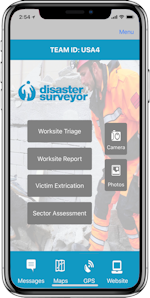
| Worksite Triage Forms | ✔︎ | ||
| Victim Extrication Forms | ✔︎ | ||
| Worksite Report Forms | ✔︎ | ||
| Sector Assessment Forms | ✔︎ | ||
| INSARAG Form PDF auto fill | ✔︎ | ||
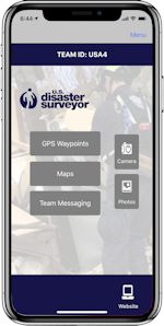
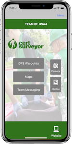
| GPS Tracking | ✔︎ | ✔︎ | ✔︎ |
| USNG Coordinates | ✔︎ | ✔︎ | |
| GPS Waypoints | ✔︎ | ✔︎ | ✔︎ |
| NAPSG v7 FEMA Waypoint Icons | ✔︎ | ✔︎ | ✔︎ |
| UN OCHA Waypoint Icons | ✔︎ | ||
| Internatinoal Waypoint Icons | ✔︎ | ||
| NAPSG v7 Waypoint fields | ✔︎ | ||
| Multiple photos per Waypoint | ✔︎ | ✔︎ | ✔︎ |
| Download in FEMA Tally Sheet | ✔︎ | ||
| Live Map saved offline | ✔︎ | ✔︎ | ✔︎ |
| Load PDF maps | ✔︎ | ✔︎ | ✔︎ |
| Team Messaging | ✔︎ | ✔︎ | ✔︎ |