System Features
Disaster Surveyor has been designed and created with 20 years of International and Domestic Urban Search and Rescue experience. The smartphone apps are designed for rapid deployment use in the field by first responders while the Commander website is used to manage all info collected from each team member for rapid situation awareness and time critical operational decisions. Our unique approach includes building the system from the “boots-on-the-ground” first responder users, all the way up to team command at a local EOC or Base of Operations. Built around a distributed computing paradigm, all data is stored primarily on each user’s device first and foremost, rather than primarily stored centrally on our servers.
 New Premium Features:
- Ability to archive all form data (for international website only) and waypoints data (all 3) by date range.
- Ability to post waypoints data to any ESRI ArcGIS Map Layer of your choice (including those used for any Operations Dashboards).
- Ability to send SMS-based team dispatch for events.
- Ability to send SMS-based team messages inter-operably with Team Chat feature in apps and website.
Product Comparison
| Feature | International
|
U.S. Domestic
|
CERT version
|
|---|---|---|---|
| NEW Premium feature: SMS based team dispatch |
 |
|
|
| NEW Premium feature: SMS based team messaging |
|
|
|
| NEW Premium feature: Waypoints posting to any ArcGIS hosted feature layer |
|
|
|
| NEW Premium feature: Archiving Data |
|
|
|
| Worksite Triage Forms | ✔︎ | ||
| Victim Extrication Forms | ✔︎ | ||
| Worksite Report Forms | ✔︎ | ||
| Sector Assessment Forms | ✔︎ | ||
| INSARAG Form PDF auto fill | ✔︎ | ||
| GPS Tracking | ✔︎ | ✔︎ | ✔︎ |
| USNG Coordinates | ✔︎ | ✔︎ | |
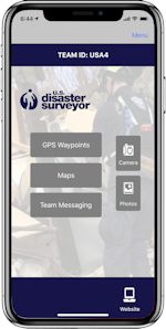
| GPS Waypoints | ✔︎ | ✔︎ | ✔︎ |
| NAPSG v7 FEMA Waypoint Icons | ✔︎ | ✔︎ | ✔︎ |
| UN OCHA Waypoint Icons | ✔︎ | ||
| Internatinoal Waypoint Icons | ✔︎ | ||
| NAPSG v7 Waypoint fields | ✔︎ | ||
| Multiple photos per Waypoint | ✔︎ | ✔︎ | ✔︎ |
| Download in FEMA Tally Sheet | ✔︎ | ||
| Live Map saved offline | ✔︎ | ✔︎ | ✔︎ |
| Load PDF maps | ✔︎ | ✔︎ | ✔︎ |
| Team Messaging | ✔︎ | ✔︎ | ✔︎ |