- To open the Settings screen, from the app home screen, tap “menu” in the upper right, then choose “Settings”. You will be displayed the Settings screen (figure 47).
- The “Logged in as:” displays which email address account is currently logged into the app.
- “Use Low Bandwidth” setting: When set to “On”, the app will only upload minimal text based data for each of the forms to the server to save on data. When set to “off”, any photos saved to forms or waypoints are also uploaded to the server.
- “Offline Mode” setting: When set to “On”, the app will generate raw JSON code to share between devices for each form’s sharing option. Using Airdrop via Bluetooth or other device to device connection, the app can share form data directly to another user’s device with Disaster Surveyor installed. (Note: For iOS, offline sharing between devices is done through Airdrop. On the recipient side, the link shared should be opened in notes or an app that will show the link as a hyperlink, then tapping the link will automatically open the form in the app.)
- “UI Language” setting: This change the interface Language as well as the INSARAG forms to a different language. Currently supported languages are English and Spanish (figure 50).
- “GPS Tracking Interval” setting: This is the GPS tracking interval time that the app waits before querying the location services of the app for the current geolocation coordinates.
- “GPS Tracking Distance” setting: This is the minimum distance delta that the device geolocation services must report back to save a position during tracking.
- “Compass Calibration” setting: When turned “On”, the device will display the compass calibration tool for each device platform when compass calibration is needed. This is turned “off” by default to prevent excess compass calibrations during most use cases.
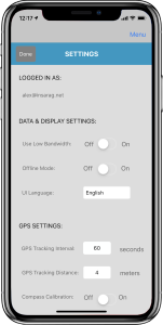 Figure 47. App Settings |
 Figure 50. Spanish interface |